Before Portuguese navigators “named” the South China Sea, the sea was known as the Champa Sea, after the Cham people who established a kingdom in Central Vietnam from the late 2nd to the 17th century. The ancestors of the Chams spoke a language derived from the Austronesian language, from which the Tagalog language is also derived.
Interactive Map Instructions Click on the image to explore the map in detail. You can zoom in to see intricate details and pan left, right, top, or bottom. Press ESC on your keyboard to exit the interactive map.
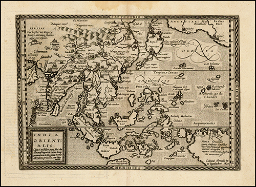
1572 Indiae Orientalis Insularumque Adiacientium Typus
1578 Asiae Novissima Tabula. Published in 1578 in Antwerp by Gerard De Jode. The map, pre-dating Ortelius’ map of China (1584), shows one of the earliest obtainable depictions of the Philippines, not yet collectively named, although many individual islands are named. This map also shows geographic features referred to as “Pulo”. “Pulo” in Tagalog means an “island, isolated place.” This digital reproduction is from Barry Lawrence Ruderman Antique Maps, Inc. Source: https://www.raremaps.com/gallery/detail/45822/Asiae_Novissima_Tabula/De%20Jode.html
1596 Jan Huygen Van Linschoten: Exacta & Accurata Delineatio cum Orarum Maritimarum tum etjam locorum terrestrium quae in Regionibus China, Cauchinchina, Camboja sive Champa, Syao, Malacca, Arracan & Pegu.
1596 Jan Huygen Van Linschoten: Exacta & Accurata Delineatio cum Orarum Maritimarum tum etjam locorum terrestrium quae in Regionibus China, Cauchinchina, Camboja sive Champa, Syao, Malacca, Arracan & Pegu. Published in 1596 in London by Jan Huygen Van Linschoten. This map shows several geographic features referred to as “Pulo”. “Pulo” in Tagalog means an “island, isolated place.” This digital reproduction is from Barry Lawrence Ruderman Antique Maps Inc. Source
1598 Asia Partiu Orbis Maxima MDXCVIII
1598 Asia Partiu Orbis Maxima MDXCVIII. Published in 1598 in Cologne by Matthias Quad and Johann Bussemachaer. This map shows several geographic features referred to as “Pulo”. “Pulo” in Tagalog means an “island, isolated place.” This digital reproduction is from Barry Lawrence Ruderman Antique Maps, Inc. Source: https://www.raremaps.com/gallery/detail/3540/Asia_Partiu_Orbis_Maxima_MDXCVIII/Quad-Bussemachaer.html1600 India Orientalis by Bussechamer
1600 India Orientalis by Bussechamer
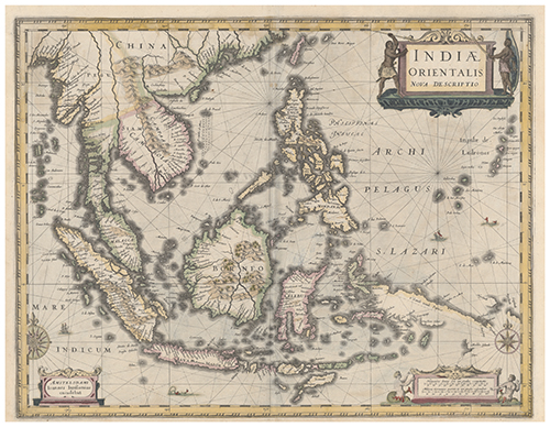
1606 India Orientalis by Hondius. Published in 1600 in Cologne by Johann Bussemachaer. This map shows several geographic features referred to as “Pulo”. “Pulo” in Tagalog means an “island, isolated place.” This digital reproduction is from Barry Lawrence Ruderman Antique Maps, Inc. Source: https://www.raremaps.com/gallery/detail/35210/India_Orientalis_1600/Bussemachaer.html
1606 India Orientalis by Hondius
Indiae Orientalis Nova Descriptio. Published in 1606 in Amsterdam by Jodocus Hondius. This map shows several geographic features referred to as “Pulo”. “Pulo” in Tagalog means an “island, isolated place.” This digital reproduction is from Barry Lawrence Ruderman Antique Maps, Inc. Source: https://www.raremaps.com/gallery/detail/25974/India_Orientalis/Hondius.html
As early as 1630, ancient maps depicted unnamed maritime features lying off the coast of “Paragua” or “Paragoa,” the old Spanish name of Palawan, an island of the Philippines. There are about 750 maritime features lying off the coast of Palawan. Most are submerged at all times while others are exposed only at low tide. Only 28 features remain above water at high tide. The largest high-tide feature, Itu Aba, is only 0.43 square kilometers. The rest range in size from 0.36 square kilometers, Pagasa, to less than 2 square meters. These maritime features, the lowest parts of the Philippine island of Palawan, are the Spratlys.
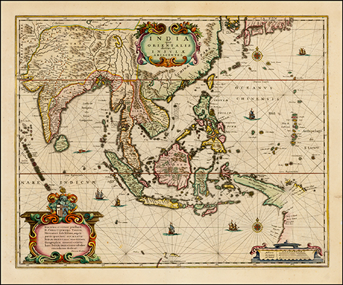
1630 Indiae Orientalis Nova Descriptio
1630 Indiae Orientalis Nova Descriptio. Published in 1630 in Amsterdam by Jan Jansson. This is an important early map of Southeast Asia and the Philippines. This map also shows the unnamed Spratlys as part of the Philippines. This digital reproduction is from Barry Lawrence Ruderman Antique Maps, Inc. Source: https://www.raremaps.com/gallery/detail/45716/Indiae_Orientalis_Nova_Descriptio/Jansson.html
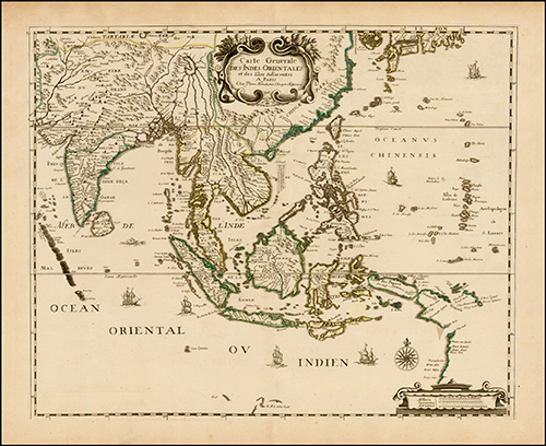
1635 India quae Orientalis dicitur et Insulae Adiacentes
1662 Tabula Indiae Orientalis. Published in Amsterdam in 1662 by Fredrick de Wit. This map shows Hainan Island as the southernmost territory of China. This map also shows the unnamed Spratlys as part of the Philippines. This digital reproduction is from Barry Lawrence Ruderman Antique Maps, Inc. Source: http://www.raremaps.com/gallery/archivedetail/0555/Tabula_Indiae_Orientalis/De%20Wit.html
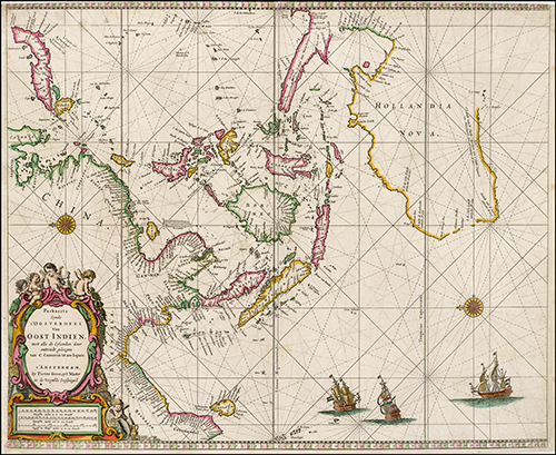
1662 Paskaerte Zynde t'Oosterdeel Van Oost Indien, met alle de Eylanden daer ontrendt geleegen van C. Comorin tota aen Iapan
1669 Pas-Pas-caert Van't Westelyckste Deel van Oost Indien En de Eylanden daer onder Begrepen
1669 Pas-Pas-caert Van't Westelyckste Deel van Oost Indien En de Eylanden daer onder Begrepen. Published in 1669 in Amsterdam by Hendrick Doncker. The map shows the unnamed Spratlys as part of the Philippines. This map also shows several geographic features referred to as “Pulo”. “Pulo” in Tagalog means an “island, isolated place.” This digital reproduction is from Barry Lawrence Ruderman Antique Maps, Inc. Source: https://www.raremaps.com/gallery/detail/45910/Pascaert_Vant_Oostelyckste_Deel_van_Oost_Indien_met_alle_de_Eylanden_daer/Doncker.html
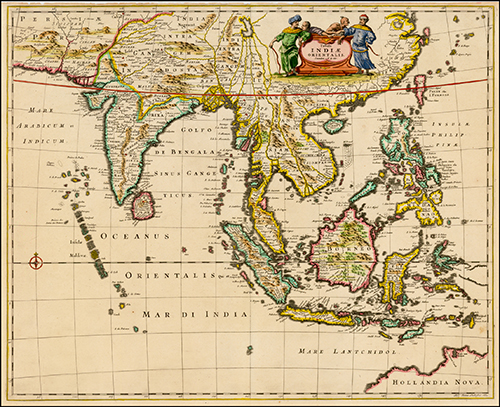
1670 Indiae Orientalis nec non Insularum Adiacentium Nova Descriptio
1677 Carte des Indes Orientales. Published in Paris in 1677 by Pierre Du Val. This map shows “Ainan” or Hainan Island as the southernmost territory of China. This map also shows the unnamed Spratlys as part of the Philippines. This digital reproduction is from Barry Lawrence Ruderman Antique Maps, Inc. Source: https://www.raremaps.com/gallery/detail/38353/Carte_des_Indes_Orientales_1677/Du%20Val.html
1683 Isole Dell'India cioe le Molucche la Filippine e della Sonda Parte de Paesi di nuova scoperta e l'Isole de Ladri ne Mare del Zud
1693 Carte des Costes de L'Asie Sur L'Ocean Contenant les Bancs Isle et Costes &c. (Indian Ocean, Southeast Asia & Western Pacific)
1693 Carte des Costes de L'Asie Sur L'Ocean Contenant les Bancs Isle et Costes &c. (Indian Ocean, Southeast Asia & Western Pacific). Published in Venice in 1690 by Vincenzo Mortier. This map shows Hainan Island as the southernmost territory of China. This map also shows the unnamed Spratlys as part of the Philippines. This digital reproduction is from Barry Lawrence Ruderman Antique Maps, Inc. Source: https://www.raremaps.com/gallery/detail/36216/-Carte_des_Costes_de_LAsie_Sur_LOcean_Contenant_les_Bancs_Isle_et_Costes/Mortier.html
1700 L'Inde De La Le Gange Suivant les Nouvelles Observations (Malaysia, Straits of Malaca, Southeast Asia, Borneo, etc.)
1700 L'Inde De La Le Gange Suivant les Nouvelles Observations (Malaysia, Straits of Malaca, Southeast Asia, Borneo, etc.). Published in Amsterdam in 1700 by Pieter Vander Aa. This map shows Hainan Island as the southernmost territory of China. This map also shows the unnamed Spratlys as part of Palawan. This digital reproduction is from Barry Lawrence Ruderman Antique Maps, Inc. Source: https://www.raremaps.com/gallery/detail/3812/LInde_De_La_Le_Gange_Suivant_les_Nouvelles_Observations_Malaysia/Vander%20Aa.html
1702 Insulae Indicae Cum Terris Circumvicinis
1702 Insulae Indicae Cum Terris Circumvicinis. Published in Munich in 1710 by Heinrich Scherer. This map shows Hainan Island as the southernmost territory of China. This map also shows the unnamed Spratlys as part of the Philippines. This digital reproduction is from Barry Lawrence Ruderman Antique Maps, Inc. Source: https://www.raremaps.com/gallery/detail/4262/Insulae_Indicae_Cum_Terris_Circumvicinis/Scherer.html
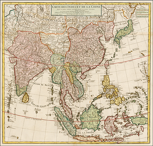
1705 Carte Des Indes et de la Chine Dressee sur plusieurs Rectifees par quelques Observations Par Guillaume De L'Isle de l'Academie Royale des Sciences
1705 Carte Des Indes et de la Chine Dressee sur plusieurs Rectifees par quelques Observations Par Guillaume De L'Isle de l'Academie Royale des Sciences. Published in Paris in 1705 by Philippe Buache. This map shows Hainan Island as the southernmost territory of China. This map also shows the unnamed Spratlys as part of the Philippines. This digital reproduction is from Barry Lawrence Ruderman Antique Maps, Inc. Source : https://www.raremaps.com/gallery/detail/34563/-Carte_Des_Indes_et_de_la_Chine_Dressee_sur_plusieurs_Rectifees_par_quelques/Buache.html
1710 (Australia and Indian Ocean) Carte des Costes de L'Asie sur L'ocean Contenant les Bancs Isles et Costes &c.
1710 (Australia and Indian Ocean) Carte des Costes de L'Asie sur L'ocean Contenant les Bancs Isles et Costes &c. Published in Amsterdam in 1710 by Johannes Covens and Corneille Mortier. This map shows Hainan Island as the southernmost territory of China. This map also shows the unnamed Spratlys as part of the Philippines. This digital reproduction is from Barry Lawrence Ruderman Antique Maps, Inc. Source: https://www.raremaps.com/gallery/detail/40896/Australia_and_Indian_Ocean_Carte_des_Costes_de_LAsie_sur_Locean/Covens-Mortier.html
1724 Tabula Indiae Orientalis et Regnorum Adjacentium J. Van Braam et G. onder de Linden
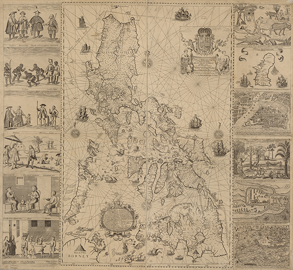
1734 Murillo Velarde Map. Published in 1734 in Manila by the Jesuit Pedro Murillo Velarde. This is the oldest map that gives a name to “Los Bajos de Paragua,” literally the shoals of Paragua. Paragua is the Spanish name for the island of Palawan. This map shows the Spratlys as part of the Philippines. This map is considered the “mother of all Philippine maps.” Source: (U.S. Library of Congress (Catalog No. 2013585226; Digital ID g8060ct003137)).
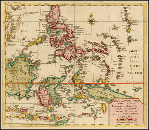
1740 Nuova et Accurata Carta dell' Isole Filippine, Ladrones, a Moluccos o Isole della Speziarie come anco Celebes &c.
1744 Carta Hydrographica y Chorographica de las Yslas Filipinas
1744 Carta Hydrographica y Chorographica de las Yslas Filipinas. Published in 1744 in Manila by the Jesuit Pedro Murillo Velarde. A second and smaller edition of the “Carta Hydrographica y Chorographica de las Yslas Filipinas.” This 1744 Murillo map, reduced version of the 1734 map, does not have the vignettes or scenes of people and places in the archipelago that appear in the 1734 map. The map is signed by the engraver, Nicholas dela Cruz Bagay. This map also shows the unnamed Spratlys as part of the Philippines. Source: (National Library of Australia (Bib ID 1958890, map G8061. S1 1744)).
1750 Archipel Des Indes Orientales, qui comprend Les Isles De La Sonde, Moluques et Philippines, tirees des Cartes du Neptune Oriental
1750 Archipel Des Indes Orientales, qui comprend Les Isles De La Sonde, Moluques et Philippines, tirees des Cartes du Neptune Oriental. Published in 1750 in Paris by Didier Robert de Vaugondy. This map shows Hainan Island as the southernmost territory of China. This map also shows the unnamed Spratlys as part of the Philippines. This digital reproduction is from Barry Lawrence Ruderman Antique Maps, Inc. Source: https://www.raremaps.com/gallery/detail/45544/Archipel_Des_Indes_Orientales_qui_comprend_Les_Isles_De_La_Sonde_Moluques/De%20Vaugondy.html
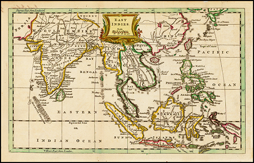
1752 East Indies
1752 East Indies. Published in 1752 in London by Thomas Jefferys. This map shows Hainan Island as the southernmost territory of China. This map also shows the unnamed Spratlys as part of the Philippines. This digital reproduction is from Barry Lawrence Ruderman Antique Maps, Inc. Source: https://www.raremaps.com/gallery/detail/40989/East_Indies/Jefferys.html
1760 Carte Hydrographique & Chorographique des Isles Philippines Dediee a Sa. Majeste Catholique, par le Brigadier Don Ferdinand Valdes Tamon . . . Dressee par le R. Pere Pierre Murillo Velarde . . . Tiree de la Original, et reduite en cette forme per George Maurice Lowitz
1760 Carte Hydrographique & Chorographique des Isles Philippines Dediee a Sa. Majeste Catholique, par le Brigadier Don Ferdinand Valdes Tamon . . . Dressee par le R. Pere Pierre Murillo Velarde . . . Tiree de la Original, et reduite en cette forme per George Maurice Lowitz. Published in 1760 in Nuremberg by George M. Lowitz based on the Murillo map. This map shows the Spratlys, Los Bajos de Paragua, as part of the Philippines. This digital reproduction is from Barry Lawrence Ruderman Antique Maps, Inc. Source: https://www.raremaps.com/gallery/detail/35555/Carte_Hydrographique_and_Chorographique_des_Isles_Philippines_Dediee_a_Sa/Lowitz-Homann%20Heirs.html
1770 A Map of the East India Islands, agreeable to the most approved Maps and Charts
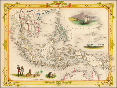
1851 Malay Archipelago, or East India Islands. Published in London in 1851 by John Tallis. This map shows Hainan Island as the southernmost territory of China. This map also shows the Spratlys as part of the Philippines. This digital reproduction is from Barry Lawrence Ruderman Antique Maps, Inc. Source: https://www.raremaps.com/gallery/detail/3674/Malay_Archipelago_or_East_India_Islands/Tallis.html
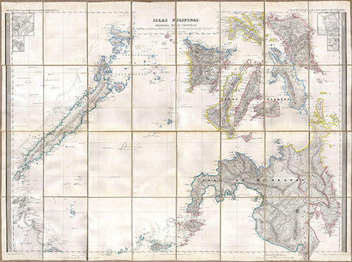
1852 Islas Filipinas
1852 Islas Filipinas. Published in 1852 in Madrid by D. Antonio Morata and D. Francisco Coello. This map is one of three parts of a map of the entire Philippines and is one of the most detailed 19th century Spanish maps of the Philippines. This map shows the unnamed Spratlys as part of the Philippines.Source: (National Library of Australia (Bib ID 3639193, map-rm 1608)).
1857 East Indies
1857 East Indies. Published in New York in 1857 by Joseph Hutchins Colton. This map shows Hainan Island as the southernmost territory of China. This map also shows the unnamed Spratlys as part of the Philippines. This digital reproduction is from Barry Lawrence Ruderman Antique Maps, Inc. Source: https://www.raremaps.com/gallery/detail/40878
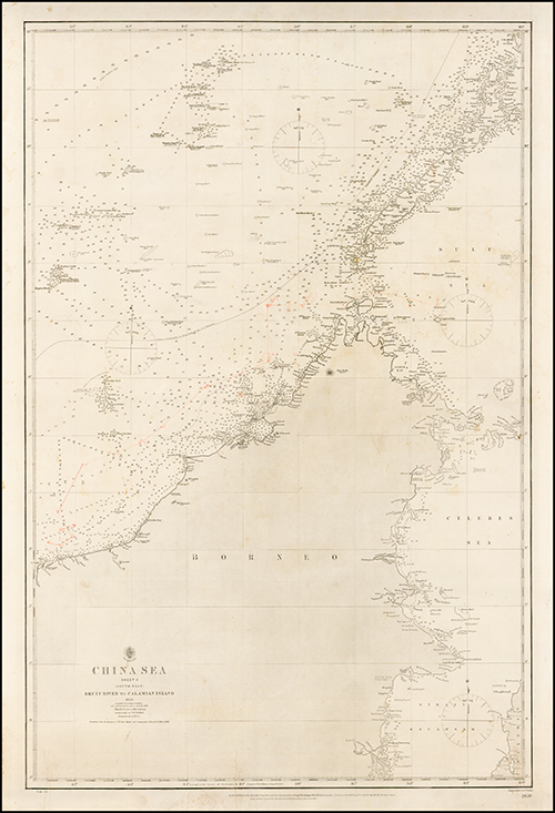
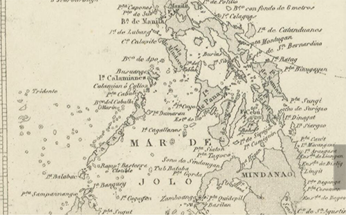
1859 China Sea. Sheet II (South East), Bruit River to Calamian Island
1860 Borneo, Iles De La Sonde, Celebes, Moluques, et Philippines
1860 Borneo, Iles De La Sonde, Celebes, Moluques, et Philippines. Published in 1860 in Paris by F.A. Garnier. This map shows Hainan Island as the southernmost territory of China. This map also shows the Spratlys as part of the Philippines. This digital reproduction is from Barry Lawrence Ruderman Antique Maps, Inc.Source: http://www.raremaps.com/gallery/detail/24445/Borneo_Iles_De_La_Sond
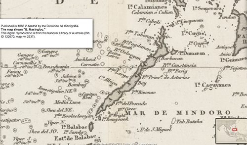
1865 Hidrographia Carta Esferica del Oceano Indio
1865 Hidrographia Carta Esferica del Oceano Indio. Published in 1865 in Madrid by Direccion de Hidrografia. This map shows the Spratlys as part of the Philippines.Source: (National Library of Australia (Bib ID 122670, map-rm 2237)).
1865 Hidrographia Carta Esferica del Oceano Indio
1865 Hidrographia Carta Esferica del Oceano Indio. Published in 1865 in Madrid by Direccion de Hidrografia.Source: (National Library of Australia (Bib ID 122670, map-rm 2237)).
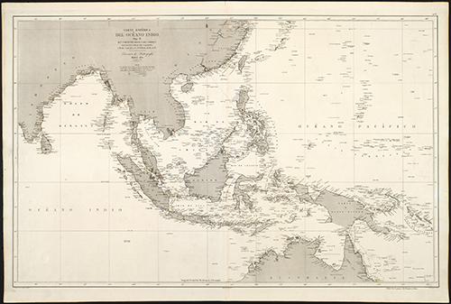
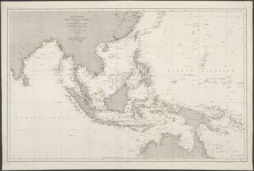
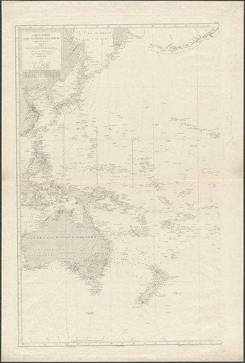
1871 Hidographia Carta General del Oceano Indico
1871 Hidographia Carta General del Oceano Indico. Published in 1871 in Madrid by Seccion de Hidrografia. This map shows Hainan Island as the southernmost territory of China. This map also shows the Spratlys as part of the Philippines. Source: (National Library of Australia (Bib ID 2823213, map-rm 2235)).
1871 Hidographia Carta General del Oceano Indico
Published in 1871 in Madrid by Seccion de Hidrografia. Source: (National Library of Australia (Bib ID 2823213, map-rm 2235)).
1876 Ost-Indien
1876 Ost-Indien. Published in Gotha in 1876 by Adolph Stieler. This map shows the Spratlys as part of the Philippines. This digital reproduction is from Barry Lawrence Ruderman Antique Maps, Inc. Source : https://www.raremaps.com/gallery/detail/25497
1896 Asiatic Archipelago (Philippines, etc) Published in 1896 in London by Edward Stanford. This map shows Hainan Island as the southernmost territory of China. This map also shows the Spratlys as part of the Philippines. This digital reproduction is from Barry Lawrence Ruderman Antique Maps, Inc. Source: https://www.raremaps.com/gallery/detail/41399/Asiatic_Archipelago_Philippines_etc/Stanford.html
1897 Hidographia Carta General del Oceano
1897 Hidographia Carta General del Oceano. Published in 1897 in Madrid by the Seccion de Hidrografia. This map shows the Spratlys as part of the Philippines. Source: (National Library of Australia (Bib ID 1449962, map-rm3380)).
1897 Hidographia Carta General del Oceano
1897 Hidographia Carta General del Oceano. Published in 1897 in Madrid by the Seccion de Hidrografia. Source: (National Library of Australia (Bib ID 1449962, map-rm3380)).