The Philippine government’s official mapping authority has issued a statement reaffirming how the country’s maritime jurisdiction — particularly in the West Philippine Sea — is represented in official maps and nautical charts. The clarification outlines the legal, technical, and international standards governing how Philippine maritime boundaries are depicted and maintained.
NAMRIA affirms consistent use of “West Philippine Sea” in official maps
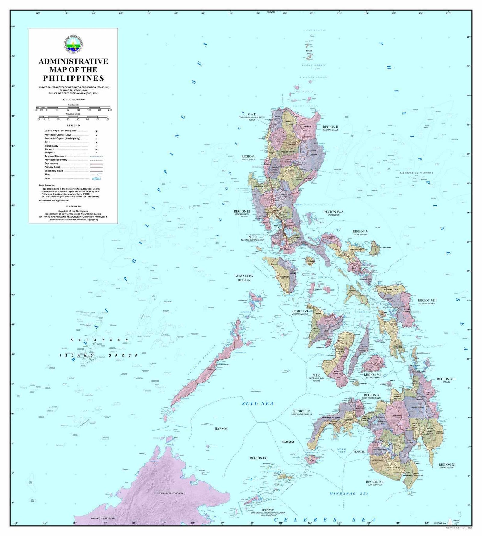
The National Mapping and Resource Information Authority (NAMRIA) reiterated that since 2012, the name “West Philippine Sea” has been formally adopted in government publications. In line with this policy, the label appears consistently across official administrative maps, topographic maps, thematic maps, and nautical charts used for navigation.
NAMRIA emphasized that these materials serve as practical and technical references for mariners, planners, researchers, institutions, and navigation systems both domestically and internationally.
Clarification on Exclusive Economic Zone representation
Addressing public discussions, NAMRIA explained how the country’s Exclusive Economic Zone (EEZ) is depicted.
Under international law, the EEZ extends up to 200 nautical miles from the Philippines’ archipelagic baselines. The resulting boundary forms a continuous curved line — similar to the edge of a circle — rather than a polygon composed of straight segments.
Because of this, NAMRIA noted that a simple list of coordinates would not accurately describe the maritime limit. Instead, the boundary is represented using precise geospatial data derived from archipelagic baselines defined under Republic Act No. 9522. This allows navigation systems and mapping software to compute and determine limits correctly.
Compliance with international hydrographic standards
NAMRIA’s nautical charts follow established international hydrographic standards and are used by both Philippine and foreign vessels navigating within Philippine jurisdiction.
The agency also submits its charts to relevant international technical bodies, including the International Hydrographic Organization. Through these processes, Philippine geographic information is integrated into the global maritime record and supports safe navigation and responsible maritime activity.
Commitment to sovereignty and safety
NAMRIA reaffirmed its mandate to produce accurate and reliable geospatial information for the country. By maintaining scientifically correct maps and internationally compliant nautical charts, the agency contributes to maritime safety, environmental management, disaster preparedness, and proper documentation of national territory.
The agency stated it will continue upholding this mandate in support of national sovereignty, maritime safety, disaster preparedness, and sound resource management.
Official Map Download
The full high-resolution administrative map may be downloaded from NAMRIA through the following link: