Historical Truths and Lies: Scarborough Shoal in Ancient Maps
A Cartographic Exhibit
Based on the 06 June 2014 Lecture of
Supreme Court Senior Associate Justice Antonio T. Carpio
Interactive Map Instructions
Click on the image to explore the map in detail. You can zoom in to see intricate details and pan left, right, top, or bottom. Press ESC on your keyboard to exit the interactive map.
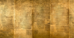
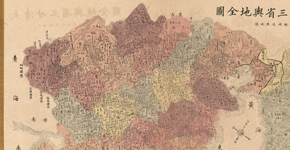
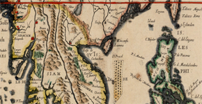
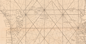
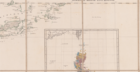
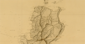
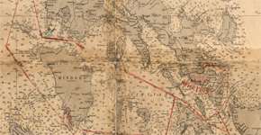
Carta Hydrographica Y Chorographica de las Yslas Filipinas

Map attached to China’s Notes Verbale Nos. CML/17/2009 and CML/18/2009
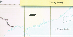
Official Chinese Map of the South China Sea with the nine-dotted line
“Maps merely constitute information which varies in accuracy from case to case; of themselves, and by virtue solely of their existence, they cannot constitute a territorial title, that is, a document endowed by international law with intrinsic legal force for the purpose of establishing territorial rights.”
Burkina Faso/Republic of Mali (1986 I.C.J. 554)
Thus, a state cannot enlarge its rights under international law by its own unilateral acts or domestic legislation. Yet, this is exactly what China did in 1947 when China drew its nine- dashed line map in the South China Sea, claiming as basis historical facts.
Despite the irrelevance of historical facts to present-day maritime claims under the United Nations Convention on the Law of the Sea, ancient maps of China made by Chinese authorities, Chinese individuals or foreigners, and ancient maps of the Philippines made by Westerners, Philippine authorities or individuals, vividly present the actual historical facts in the South China Sea.
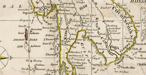
Hua Yi Tu” or Map of China and the Barbarian Countries
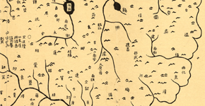
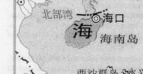
This map shows Hainan Island as the southernmost territory of China.
The annotations on the sides of this map are not part of the stone engraving.
This digital reproduction is from the U.S. Library of Congress (Catalogue No.2002626771; Digital ID g7820 ct000284).
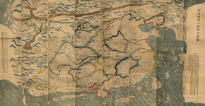
“DA MING HUN YI TU” or the Great Ming Dynasty Amalgamated Map
The map shows Hainan Island as the southernmost territory of China.
The original of the map is with the First Historical Archive of China in Beijing. This digital reproduction is from Wikimedia Commons, which sourced its copy from the library of the Hong Kong Baptist University. (http://geog.hkbu.edu.hk/ geog1150/chinese/catalog/am31_map1.htm).
“DA MING YU DI TU” or the Atlas of the Ming Empire

The map shows Hainan Island as the southernmost territory of China.
This digital reproduction is from the U.S. Library of Congress (Catalog No. 2002626776; Digital ID g7820m gct00125).
Since the start of the Song Dynasty in 960 AD until the end of the Qing Dynasty in 1912, or for almost a millennium, the southernmost territory of China has always been Hainan Island based on all official and unofficial maps of China.
And as late as 1932, the Chinese Government in a Note Verbale to France reiterated to the world that the southernmost territory of China is Hainan Island.
“TIAN DI TU” or the Atlas of Heaven and Earth

This map shows Hainan Island as the southernmost territory of China.
This digital reproduction is from the U.S. Library of Congress (Catalog No. 200262625; Digital ID g7820m gct00225
“KUN YU WAN GUO QUAN TU” or A Map of the Myriad Countries of the World
This map shows Hainan Island as the southernmost territory of China.
This digital reproduction is from the U.S. Library of Congress (Catalog No. 2010585650; Digital ID g3200 ex000006Za,b and g3200m gex00001).
Selden Map of China
This map shows Hainan Island as the southernmost territory of China.
This digital reproduction is from the Bodleian Library of the University of Oxford (http://seldenmap.bodleian. ox.ac.uk/map).
“DA QING WAN NIAN YI TONG TIAN XIA QUAN TU” or The Great Qing Dynasty’s Complete Map of All Under Heaven
“DA QING WAN NIAN YI TONG DI LI QUAN TU”
or the Complete Geographical Map of the Great Qing Dynasty

This map shows Hainan Island as the southernmost territory of China.
Revised edition based on the original map drawn by Huang Qianren in 1767. This digital reproduction is from the U.S. Library of Congress (Catalog No. gm71005060; Digital ID g7820 ct002256).
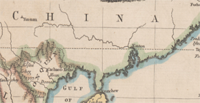
“GUANGDONG TONG SHENG SHUI DAO TU”
or Map of the Waterways of Guangdong Province
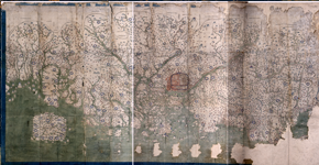
This map shows Hainan Island as the southernmost part of Guangdong province.
This digital reproduction is from the U.S. Library of Congress (Catalog No. gm71002467; Digital ID g7823g ct003406).
“GUANGDONG QUAN TU” or the Complete Map of Guangdong Province
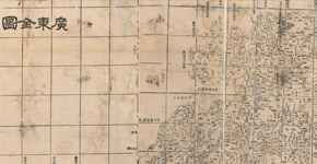
This map shows Hainan Island as the southernmost part of Guangdong province.
This digital reproduction is from the U.S. Library of Congress (Catalogue No. gm71005120; Digital ID g7823g ct003391).
“DA QING ER SHI SAN SHENG YU DI QUAN TU” or the Complete Map of the Twenty- Three Provinces of the Great Qing Dynasty
This map shows Hainan Island as the southernmost territory of China.
This digital reproduction is from the U.S. Library of Congress (Catalog No. gm71005068; Digital ID g7820 ct003427).
“GUANGDONG QUAN SHENG SHUI LU YU TU” or Map of the Waterways and Roads in Guangdong Province
“HUANG CHAO ZHI SHENG YU DI QUAN TU” or the Qing Empire’s Complete Map of All Provinces (3441×2972) 1896 AD “Huang Chao Zhi Sheng Yu Di Quan Tu”
This map shows Hainan Island as the southernmost territory of China.
This digital reproduction is from the U.S. Library of Congress (Catalog No. gm71005083; Digital ID g7820 ct003428).
“ZHONG HUA GUO CHI DI TU”

This map shows Hainan Island as the southernmost territory of China.
This digital reproduction is from the U.S. Library of Congress (Catalog No. 2007628129; Digital ID g7821f ct002301).
“ZHONGHUA MIN GUO FEN SHENG XIN TU” or the Map of the Provinces of China
This map shows Hainan Island as the southernmost territory of China.
This digital reproduction is from the U.S. Library of Congress (Catalog No. 2006629696; Digital ID g7821f ct002303).
“CARTE EXACTE DE TOUTES LES PROVINCES, VILLES, BOURGS, VILLAGES ET RIVIERES DU VASTE ET PUISSANT EMPIRE DE LA CHINE” or An Accurate Map of All the Provinces, Cities, Towns, Villages and Rivers of the Vast and Powerful Chinese Empire
This map shows Hainan Island as the southernmost territory of China.
This digital reproduction is from the U.S. Library of Congress (Catalog No. 87691057; Digital ID g7810 ct002857).
“CARTE LA PLUS GENERALE ET QUI COMPREHEND LA CHINE, LA TARTARIE CHINOISE, ET LE THIBET” or A General Map that Includes China, Chinese Tartary and Tibet
This map shows Hainan Island as the southernmost territory of China.
This digital reproduction is from the National Library of Australia (Bib ID 2333624, Map Section at RM 3521).
Scarborough Shoal is more than 500 NM from Hainan Island, at the other end of the South China Sea.
“CARTE DE L’EMPIRE DE LA CHINE, DE LA TARTARIE CHINOISE, ET DU ROYAUME DE CORÉE, AVEC LES ISLES DU JAPON”

This map shows ‘Scarboro’ shoal.
This digital reproduction is from the private collection of Atty. Anne Marie Corominas of Manila and Cebu.
“CARTE DE L’EMPIRE CHINOIS ET DU JAPON” or A French Map of the Chinese Empire together with Japan
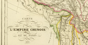
This map shows Hainan Island as the southernmost territory of China.
This digital reproduction is from Wikimedia Commons (http:// en.wikipedia.org/wiki/File:L%27Empire_Chinois_et_ du_Japon_%281833%29.jpg).
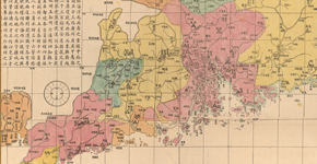
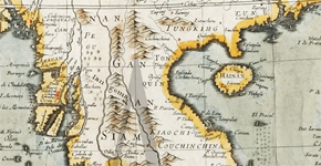
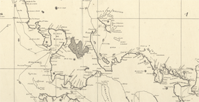
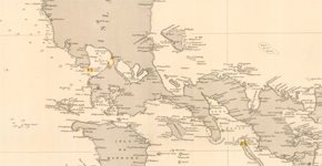
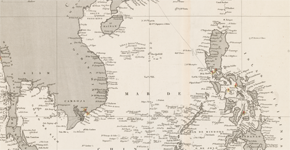
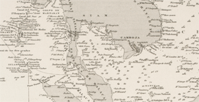
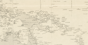
All the maps of the Philippines, from 1636 to 1940, a period of 304 years, consistently show Scarborough Shoal, whether named or unnamed, as part of the Philippines.
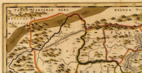
CHINA VETERIBUS SINARUM REGIO NUNC INCOLIS TAME DICTA
On the western side off the coast of Central Luzon, there is an unnamed shoal below the words “P. de Mandato.” The Spanish phrase “P. de Mandato” means the point of command – which implies there was a Spanish military garrison in that coastal place. The unnamed shoal off this coastal place would later be called “Panacot” by the Jesuit Pedro Murillo.
This digital reproduction is from Barry Lawrence Ruderman Antique Maps, Inc. (http://www. raremaps.com/gallery/detail/36716).
CARTE GENERALE DES INDES ORIENTALES ET DES ISLES ADIACENTES
On the western side off the coast of Central Luzon, there is an unnamed shoal below the words “P. de Mandato.” This unnamed shoal would later be called Panacot.
This digital reproduction is from Barry Lawrence Ruderman Antique Maps, Inc. (http://www. raremaps.com/gallery/detail/30701/Carte_ Generale_Des_Indes_Orientales_et_des_ Isles_Adi acentes/Mariette.html).
TABULA INDIAE ORIENTALIS

This digital reproduction is from Barry Lawrence Ruderman Antique Maps, Inc. (http://www. raremaps.com/gallery/archivedetail/0555/Tabula_Indiae_ Orientalis/De%20Wit.html).
INDIAE ORIENTALIS NEC NON INSULARUM ADIACENTUM NOVA DESCRIPTIO

On the western side off the coast of Central Luzon, there are two unnamed shoals below the words “P. de Mandato.” One of these two shoals would later be called Panacot.
This digital reproduction is from Barry Lawrence Ruderman Antique Maps, Inc. (https://www.raremaps.com/ gallery/detail/35549/ Indiae_Orientalis_nec_ non_Insularum_Adiacentium_Nova_
Descript io/Visscher.html).
A NEW MAP OF EAST INDIA
This digital reproduction is from Barry Lawrence Ruderman Antique Maps, Inc. (https://www.raremaps.com/gallery/detail/32192/A_ New_Map_of_East_India/ Speed.html).
INDIA ORIENTALIS ET INSULARUM ADIACENTUM ANTIQUA ET NOVA DESCRIPTIO

On the western side off the coast of Central Luzon, there is an unnamed shoal below the words “P. de Mandato.” This unnamed shoal would later be called Panacot.
This digital reproduction is from Barry Lawrence Ruderman Antique Maps, Inc. (http:// www.raremaps.com/gallery/detail/36938/ Indiae_Orientalis_et_Insularum
_Adiacentum_ Antiqua_et_Nova_Descriptio/
Cluverius.html).
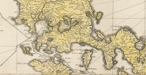
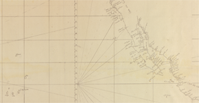
Carta Hydrographica Y Chorographica de las Yslas Filipinas
This digital reproduction is from the U.S. Library of Congress (Catalog No. 2013585226; Digital ID g8060 ct003137)
MAPA DE LAS YSLAS PHILIPINAS
INSULÆ PHILIPPINÆ EX AUTOGRAPHO, MANILÆ
The map shows “Scarboro” shoal.
This is a digital reproduction from the private collection of Atty. Anne Marie Corominas of Manila and Cebu.
CARTE HYDROGRAPHIQUE & CHOROGRAPHIQUE DES ISLES PHILIPPINES
The map shows “Panacot” shoal.
This digital reproduction is from Barry Lawrence Ruderman Antique Maps, Inc. (http://www.raremaps.com/ gallery/detail/35555/Carte_Hydrographique_ and_Chorographique_des_Isles_Philippines _Dediee_a_Sa/LowitzHomann%20Heirs.html).
A GENERAL MAP OF THE EAST INDIES AND THAT PART OF CHINA WHERE THE EUROPEANS HAVE ANY SETTLEMENTS OR COMMONLY ANY TRADE
The map shows “Panacot” shoal.
This digital reproduction is from Barry Lawrence Ruderman Antique Maps, Inc. (http://www.raremaps. com/gallery/detail/0176gh/A_General_Map_of_the_ East_Indies_and_that_Part_of_China_
where_the_ Europeans/Kitchin.html).
A NEW MAP OF THE PHILIPPINE ISLANDS, DRAWN FROM THE BEST AUTHORITIES
The map shows “Panacot” shoal.
This digital reproduction is from the private collection of Atty. Anne Marie Corominas of Manila and Cebu.
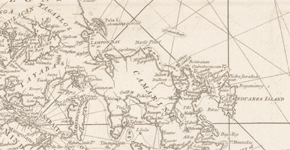
EAST INDIES
The map shows “Panacot” shoal.
This digital reproduction is from the National Library of Australia (Bib ID 3620673, map-rm1424).
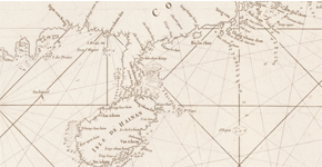
A CHART OF THE CHINA SEA
The map shows “Scarboro” shoal.
The British tea clipper Scarborough struck the rocks of the shoal on 12 September 1748, and so European cartographers named the shoal Scarborough. This digital reproduction is from the National Library of Australia (Bib ID 3770071, map- ra49-s32).
“A CHART OF THE CHINA SEA AND THE PHILIPPINE ISLANDS WITH THE ARCHIPELAGOS OF FELICIA AND SOLOO”
This digital reproduction is from the National Library of Australia (Bib ID 3667413, map-ra52-s70).
“CARTE DE LA PARTIE ORIENTALE DES PHILIPPINES AND CARTE DE LA PARTIE OCCIDENTALE DES PHILIPPINES”
“MAP OF THE PACIFIC OCEAN BETWEEN THE COAST OF CALIFORNIA AND MEXICO AND JAPAN, PHILIPPINES, AND THE COAST OF CHINA”
This map shows a shoal named “B. Mansiloc.”
This digital reproduction is from the U.S. Library of Congress (Catalog No. 91680984, Digital ID g9230 Ih000015).
ISOLE FILIPPINE
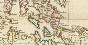
“Panacot” shoal appears on this map as in the Murillo map.
This digital reproduction is from Barry Lawrence Ruderman Antique Maps, Inc. (http:// www.raremaps.com/gallery/detail/33827).
“SECONDE PARTIE DE LA CARTE D’ASIE” or Second Part of the Map of Asia
In the later reprinted maps of Sayer, and Laurie and Whittle, Panacot is called Scarborough shoal.
This digital reproduction is from the National Library of Australia (Bib ID 3664337,Bib ID 1372672, map-ra 39).
A NEW CHART OF THE INDIAN AND PACIFIC OCEANS BETWEEN THE CAPE OF GOOD HOPE, NEW HOLLAND AND JAPAN
This map shows “Scarboro” shoal.
This digital reproduction is from the National Library of Australia (Bib ID 3507852, map-rm-451).
MAPA DE LAS ISLAS FILIPINAS
The map shows “Bco de Masingolo o’ Panacot”.
This is a digital reproduction from the private collection of Atty. Anne Marie Corominas of Manila and Cebu.
1792 CHART “PLANO DE LA NAVIGACION
This digital reproduction is from the archives of the Museo Naval de Madrid, copied by the Philippine Embassy in Madrid.
ASIA AND ITS ISLANDS ACCORDING TO D’ANVILLE
The map shows “Scarborough” shoal.
This digital reproduction is from the National Library of Australia (Bib ID 2133866, map-rm 1865).
A NEW CHART OF THE CHINA SEA AND ITS SEVERAL ENTRANCES
This map shows “Scarborough” shoal, with the words “Scarborough Sept. 12th, 1748 and “the Negroes Head.”
This digital reproduction is from the National Library of Australia (Bib ID 3620691, map-rm 1425).
CARTA GENERAL DEL ARCHIPIELAGO DE FILIPINAS
The shoal is called “Bajo de Masingloc” but the map also adds “o Scarborough.”
This digital reproduction is from the archives of the Museo Naval de Madrid, copied by the Philippine Embassy in Madrid.
EAST INDIA ISLANDS ON MERCATOR’S PROJECTION
The map shows “Scarboro” shoal.
This digital reproduction is from the National Library of Australia (Bib ID 1493073, map-rm 2639).
The map shows “Scarborough” shoal.
This digital reproduction is from the U.S. Library of Congress (Catalog No. 2006636622, Digital ID g7400 ct1990).
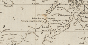
ISLAS FILIPINAS
This map shows “Bajo Masinloc.”
This digital reproduction is from the National Library of Australia (Bib ID 3639193, map-rm 1608).
CARTA GENERAL DEL ARCHIPIELAGO FILIPINO
This map shows “Bajo Masingloc o Scarborough.” There is an inset of Scarborough shoal (1866 map of Commander Wilds) on the lower left side of the map.
This digital reproduction is from the archives of the Museo Naval de Madrid, copied by the Philippine Embassy in Madrid.
CARTA ESFERICA DEL OCEANO INDIO
The map shows “B. Masingloc.”
This digital reproduction is from the National Library of Australia (Bib ID 122670, map-rm 2237).
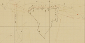
PLANO DEL BAJO MASINGLOC

This digital reproduction is from the archives of the Museo Naval de Madrid, copied by the Philippine Embassy in Madrid.
CARTA GENERAL DEL OCEANO INDICO
The map shows “B. Masingloc.”
This digital reproduction is from the National Library of Australia (Bib ID 2823213, map-rm 2235).
CARTA GENERAL DEL ARCHIPIELAGO FILIPINO
This map shows “B. Masingloc o Scarborough.”
This digital reproduction is from the archives of the Museo Naval de Madrid, copied by the Philippine Embassy in Madrid.
CARTA GENERAL DEL OCEANO PACIFICO
This map shows “B. Masingloc o Scarborough.”
This digital reproduction is from the National Library of Australia (Bib ID 1449962, map-rm3380).
ISLAS FILIPINAS – MAPA GENERAL – OBSERVATORIO DE MANILA”
The map shows “B. Masinloc.”
This digital reproduction is from the Atlas de Filipinas, Internet Archive, Ohio State University Library, (https://archive.org/stream/ AtlasDeFilipinasColleccionDe30
MapasTrabajadosPorDelineantes/ AtlasDeFilipinas#page/n27/mode/1up).
MAP OF THE PHILIPPINE ISLANDS
The map shows “Scarborough” shoal.
This digital reproduction is from the U.S. Library of Congress (Catalog No. 2013590196, Digital ID g8060 ct003965).
From the 1960s to the 1980s, U.S. military warplanes, together with Philippine Air Force warplanes, used Scarborough Shoal as an impact range when they practiced bombing runs. Neither China nor any other country protested these bombing practices by American and Philippine warplanes, despite worldwide prior Notices to Mariners, through the International Maritime Organization of the United Nations, to keep away from Scarborough Shoal during the bombing practices.
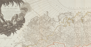
PHILIPPINE ISLANDS
The map shows “Scarborough” shoal with depth soundings.
This digital reproduction is from the U.S. Library of Congress (Catalog No. 2011592026; Digital ID g8061p ct003542).
If the Philippines can bomb a shoal repeatedly over decades without any protest from neighboring states, it certainly must have sovereignty over such shoal.
Carta Hydrographica Y Chorographica de las Yslas Filipinas
This digital reproduction is from the U.S. Library of Congress (Catalog No. 2013585226; Digital ID g8060 ct003137)